Sreeram Viswanath

Published on: Jun 24, 2026

Fmb Sketch Online

Field Measurement Book (FMB) sketch is a compilation of map data that is stored in volumes by the Government at the respective Tahsildar office. In FMB’s, the individual survey number sketches are maintained at a scale of 1:1000 or 1:2000. Each survey number is divided into various sub-divisions. Each sub-division number is owned by a property owner. FMB denotes the precise dimensions of the land. Hence, in a property purchase transaction, Fmb Sketch is used to verify the land measurements and boundaries of the property.

Obtaining Fmb Sketch

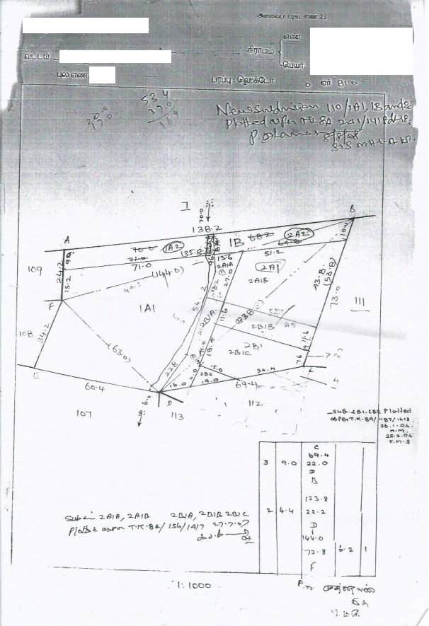
The concerned Tahsildar office maintains the FMB sketch. To obtain FMB sketch or to request the concerned Tahsildar office to survey the property, a request must be submitted in writing to the concerned Tahsildar. A sample Fmb Sketch for reference:

FMB Sketch Sample

Fmb Sketch Sample

Components of FMB

The following are the various components of FMB:

  1. G-line
  2. F-line
  3. Subdivision lines
  4. Ladder
  5. Extension lines
  6. Neighboring field survey numbers

These components are further discussed in detail:

G-line

G-line outlines the making of the entire sketch. It is an imaginary line that converts the sketch into various sizes of triangles to fix the boundary lines and the various points in the sketch.  Errors in G-line will affect all the pertinent calculations.

F-line

F-line signifies the actual field boundaries in the outer lines of the sketch. Its points are fixed with reference to its offset distance from the G-line.

Subdivision Lines

Subdivision lines demarcate a small portion of land within a survey number. A sub-divisional extent of a polygon is directly correlated to the extent found for the particular subdivision. The subdivision lines are generally defined through a ladder, or the likes of it; except for the graphical representation in FMB.

Ladder

The field line points are defined with reference to an offset distance from the G-line. The offset distance may deviate to the left or right side of the G-line. This left or right angle deviation is highlighted by the ladder. Converting the ladder details into electronic data can produce the outline of the Fmb Sketch.

Extension Lines

Each survey number field forms a crucial part of the village map, and as a result of it, other fields surround each sketch. The precise direction wherein the subject field joins the neighboring field is depicted on the FMB as an extension line.

Neighbouring Field Survey Numbers

The other fields surround each of the survey sketches. These surrounding field numbers are marked around each FMB. This facilitates the conversion of FMB’s into D-sketches, and so on and so forth.

How to Get Fmb Sketch?

To obtain an FMB sketch for a property, the concerned Tahsildar office must be approached by the landowner with a request. There is no online facility for viewing FMB sketch in Tamil Nadu currently. In case the FMB sketch is outdated or not available, a request can be made for a survey of the property. To obtain Fmb Sketch for a property, get in touch with an

IndiaFilings Property Advisor

at

sales@indiafilings.com
Back to Learn

Frequently Asked Questions

Common questions about FMB Sketch Tamil Nadu.

An FMB (Field Measurement Book) Sketch is a compilation of map data stored in volumes by the Government at the respective Tahsildar office. It is a scaled representation (typically 1:1000 or 1:2000) of individual survey numbers, where each survey number is divided into various sub-divisions owned by different property owners. The FMB Sketch denotes the precise dimensions and boundaries of the land.
In a property purchase transaction, the FMB Sketch is crucial as it is used to verify the land measurements and boundaries of the property being bought or sold. It serves as an official and legally recognized document that accurately depicts the land's dimensions, ensuring that both parties are aware of the exact extent of the property.
The main components of an FMB Sketch include G-line, F-line, subdivision lines, ladder, extension lines, and neighboring field survey numbers. These components work together to provide a comprehensive representation of the land, its boundaries, and its relation to surrounding properties.
The G-line outlines the entire sketch and serves as an imaginary line that converts the sketch into various triangles. It is used to fix the boundary lines and various points within the sketch. Any errors in the G-line can affect the calculations and measurements of the entire sketch.
To obtain an FMB Sketch for a property, you need to approach the concerned Tahsildar office with a written request. Currently, there is no online facility available in Tamil Nadu for viewing FMB Sketches. If the FMB Sketch is outdated or unavailable, you can request a survey of the property.
Yes, if the FMB Sketch for a property is not available or outdated, you can submit a request to the concerned Tahsildar office for a survey of the property. This will ensure that an up-to-date and accurate representation of the land is available.
The ladder in an FMB Sketch is used to define the field line points with reference to an offset distance from the G-line. The offset distance may deviate to the left or right side of the G-line, and the ladder highlights this left or right angle deviation. Converting the ladder details into electronic data can produce the outline of the FMB Sketch.
Each survey number field is part of the larger village map, and as a result, other fields surround each sketch. The precise direction where the subject field joins the neighboring field is depicted on the FMB as an extension line. The surrounding field numbers are also marked around each FMB Sketch to facilitate the conversion of FMB Sketches into other map formats.
FMB Sketches are typically maintained at a scale of 1:1000 or 1:2000, which means that 1 unit on the sketch represents 1000 or 2000 units on the actual ground, respectively. This scale provides a detailed and accurate representation of the land measurements.
While FMB Sketches are primarily used for verifying land measurements and boundaries during property transactions, they can also be useful for various other purposes. These may include land records management, urban planning, infrastructure development, and any other activities that require accurate and official representations of land parcels and their dimensions.